History of & Geology of Placerville
|
 PLACERVILLE, the town in El Dorado County, California where William Toombs sought his fortune, started up during the California Gold Rush as a roughshod mining camp. When gold was first found on the North Fork of the American River in January 1848, just eight miles away at nearby Sutter's Mill in Coloma, the discovery generated little interest at first, but by summer over two-thousand fortune seekers were swarming over the surrounding foothills looking for the yellow metal. Unfortunately, the Coloma diggings panned out all too quickly. So, when Indians brought word in June of rich placer deposits, just a few miles upstream, that were producing up to six ounces of gold per day per man, half the Coloma camp pulled up stakes overnight and trekked upriver to the "New Diggins".
|
|

At first, gold was everywhere at the "New Diggins", and a fortunate few struck it rich. But when the river level dropped dramatically in July, there was scarce enough water to fill the sluice boxes in camp, and the "New Diggins" soon became "Dry Diggins", then later "Old Dry Diggins" to distinguish it from another "Dry Diggins" camp to the northwest that later became Auburn. Despite low water, the riches still flowed, and tents gave way to cabins, clapboard buildings, saloons and bawdy houses; and "Old Dry Diggins" became a rough and rowdy mining town overnight. When three foreigners were hanged from an oak tree in the middle of town on October 17, 1849, Dry Diggins became "Hangtown".

An 1849 photograph of old Hangtown.
The population of Hangtown continued to grow, reaching several thousand people by 1849. Merchants and entrepreneurs moved in, wives joined husbands, families started, justice was established, and the rowdy element forced to move on. Placer mining remained the towns livelyhood, but Hangtown became more business and family oriented. Soon the residents began desiring an atmosphere of respectability, and to achieve it they renamed their town in 1854 to Placerville, in honor of the gold-bearing gravels that were its economic mainstay.

Notice that in 1866 Placerville still has dirt streets.
 When miners first made the trek to the "New Diggins" camp, they extracted the gold by panning, or by sluicing, which allowed small teams to wash the gold-bearing gravels and concentrate the flakes and nuggets. Soon more expensive operations moved in, such as hydraulic mining of the gravels in quarries using high-pressure water houses, and the digging of drift mines (horizontal tunnels) and vertical shafts to reach ancient gravels that were buried deep beneath the ground. From the middle 1850s through the 1870s, the placers proved to be extremely rich. For example, one 20-acre placer claim yielded half of the $10 million in gold produced by 1910 from the Coon Hollow district alone; and the Texas Hill and White Rock diggings by 1910 had produced $5 million each (mostly from the Deep Blue Lead Tertiary channel). The photo at the upper left, from an old glass ambrotype (similar to a daguerrotype), shows miners in 1852 using a "long Tom" to sluice gravels at Spanish Flat, a mining camp in El Dorado County just a few miles north of Placerville.
Eventually large, well-financed operations began mining directly into the bedrock, following the gold-bearing quartz veins that had sourced the placers over the millenia. Hard rock (lode) mining of these veins began as early as 1852 with the Pacific mine, but most of the hard rock mining was from the 1880s until about 1915. Some mining started up again in the 1930s, but there has been very little activity since. The total value of gold produced from this district is unknown, but the placer (gravel) mines alone were estimated by 1910 to have yielded $25 million or more.
Bedrock in the Placerville district is mosly dark metamorphic rocks, called schist, slate and greenstone, with some intrusions of a light-colored granitic rock called granodiorite that is found in the east. White Rock Canyon, on the northeast side of Placerville, is so named because it represents an area where one of these instrusions is present. Thus, the white outcrops of granodiorite stand out in marked contrast to dark slate on the southwest side of the canyon. Places at White Rock where the contact between between the slate and the granodiorite can be mined provide opportunities to look for gold veins (lode deposits). Also, ancient stream gravels eroding into this contact, and having been sourced directly by these veins, can be especially rich.
The metamorphics include a belt of gray to black slate of the Mariposa Formation (Upper Jurassic age), one to two miles wide, that runs N-S through the center the district, with greenstone and amphibolite on the west side, and schist and slate of the Calaveras Formation (Carboniferous to Permian age) on the east. The Mother Lode, which is the main band of gold-bearing quartz veins, runs right through the middle of town. The veins here are found mainly in the slate, and contain finely disseminated gold with small amounts of pyrite (fools gold). The lode-gold deposits are massive quartz veins, some 20 feet thick, with many small stringers. Although most of the ore is low- to moderate-grade (less than ¼ ounce of gold per ton), a few veins are quite rich and have been mined to depths of 2000 feet.
The placers, which is another name for the ancient stream gravels, fill channels cut into the bedrock, and into each other. The main channel of the ancestral American River is Tertiary in age (i.e., several million years old). It flowed to the west along the modern drainage of Webber Creek, which is south of Placerville, and there are numerous smaller tributaries that feed into it. Because gold is very dense, it tends to work its way downward through these gravels. Thus, the placers are richest in gold at the base, right at the contact with the bedrock, and gravel-filled cracks in the bedrock can be especially rich. In places, these gravels are capped by hard, thick beds of rhyolite tuff and andesite breccia - volcanic rocks that represent the ash falls, mud flows and lava flows of ancient volcanoes that last erupted eons ago.

An 1852 photograph showing men Working gravels on the American River near Placerville.
The placer deposits include, from SW to NE, the Diamond Springs, Coon Hollow, Texas Hill, Smith Flat, and White Rock Canyon areas. All of these old mining camps are places where the Forty-niners found ancient gold-bearing gravels, distinct and separate from the moden streams of the Placerville basin. None of these placers represent the main Tertiary channel of the American River. Instead, all of them were tributaries to the main channel.
One of the richest of several tributaries that fed the main Tertiary channel is the "Deep Blue" lead. This ancient channel first appears at Georgia Hill, northwest the Toombs Ranch. It then heads south, passing southwest of the ranch, before crossing White Rock Creek, and dipping under the volcanic rocks near Lava Cap Winery. It then emerges from beneath the cap and continues south to Three Mile House at Smith's Flat, about three miles from Placerville on the old Carson Valley Highway. The Deep Blue then crosses Hangtown Creek, swings southwest, passing north of Texas Hill, and ends near Spanish Hill about 1½ miles southeast of Placerville, where it joins the Tertiary American River, which follows Webber Creek to the south of Placerville, and several miles south of the modern South Fork of the American River. Along much of its length, the Deep Blue follows the contact between the Mariposa Slate and the granitic intrusion that underlies White Rock Canyon. The richness of the channel is probably due to erosion of many small gold-bearing veins associated with the contact zone.
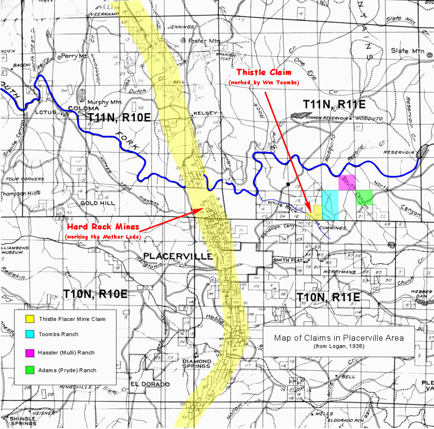
The Thistle Placer Mine that William Toombs owned is in the Deep Blue lead, which snakes along near the southwest side of the old Toombs ranch. The location of the mine is shown on Plate 2 in the California Journal of Mines & Geology, v. 34, No 3, and the Map Reference for it is 38°45'16"N by 120°44'57"W (38.75440, -120.74920). The claim is located where lava, actually the volcanic breccia of an ancient mud flow, partially covers the channel, which here is only about 30 feet wide and 12 feet thick as it runs along beneath beneath the lava cap. The actual mine may have been a shaft that pierced the lava cap to reach the gravels beneath. Then the shaft probably pierced through the gravels to reach to the underlying bedrock, where William could work the lowermost, richest part of the ancient stream bed - gravel-filled cracks on the surface of the bedrock being the best places to find concentrations of gold. The mine may have also been a drift (horizontal tunnel) that started at the edge of the lava cap, then dug along beneath the volcanic cover to reach the hidden Blue Lead gravels. William no doubt worked several claims during his forty some years in the gold fields, but the Thistle Mine appears to be the one that he concentrated on in his later years.
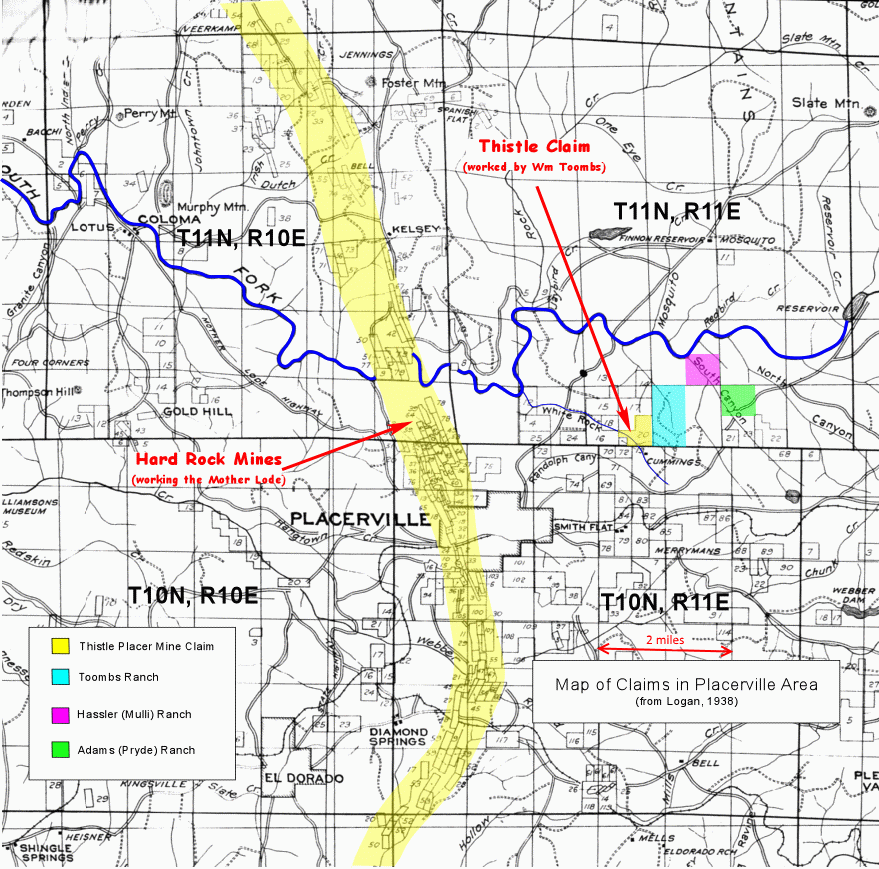
Map showing the Placerville and White Rock districts.
